What’s Stopping Us?
Bureau of Meteorology declares El Niño 'likely in coming weeks' but still not ready to say it's underway
By weather reporter Tyne Logan and meteorologist Tom Saunders at the ABC
Australia's Bureau of Meteorology has announced an El Niño event is "likely in the coming weeks", but has again held off declaring that it is underway, despite having satisfied its own criteria.
The decision puts the bureau at odds with other international weather agencies, such as the US National Ocean Atmospheric Administration (NOAA) and the World Meteorological Organization, who have said El Niño is already underway.
The major global climate driver is the opposite of La Niña, and is linked to hot, dry weather with a reputation for precipitating drought and bushfire in Australia.
The world, including many parts of eastern Australia, has just recorded the warmest July on record, and it's been two months since the first agencies declared El Niño had begun — so what is the Australian bureau waiting for?
Tourists and Parisians in the water of the Trocadero fountain at the foot of the Eiffel Tower on June 24.
Samuel Boivin
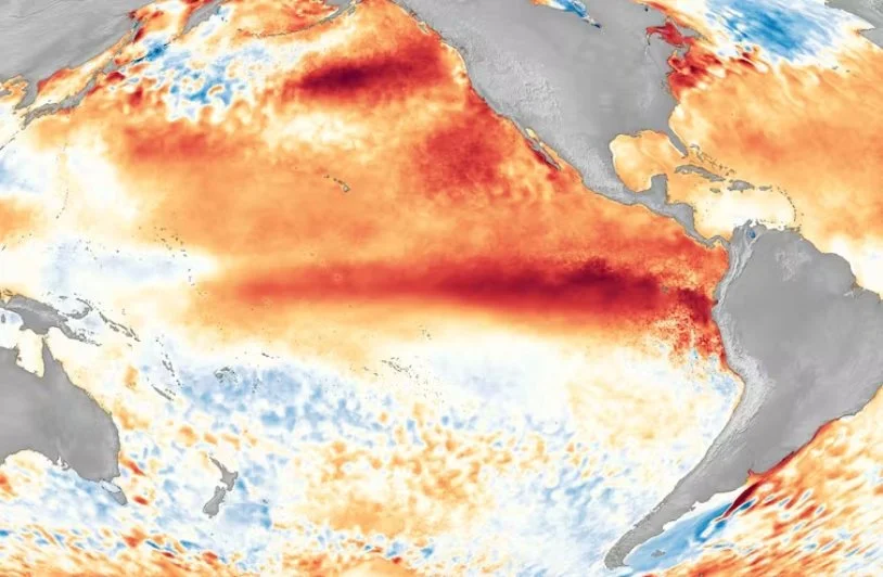
El Niño refers to a change in both the ocean and atmosphere across the Pacific region, and while the water temperatures have displayed a clear signal since autumn, there continues to be a delayed atmospheric response.
Some climatologists have referred to this interaction as a "dance" between the two systems. Right now, the ocean is dancing on its own.
Atmospheric indicators
There are a few indicators used to judge the state of the atmosphere over the Pacific, and none are currently showing a strong El Niño signal.
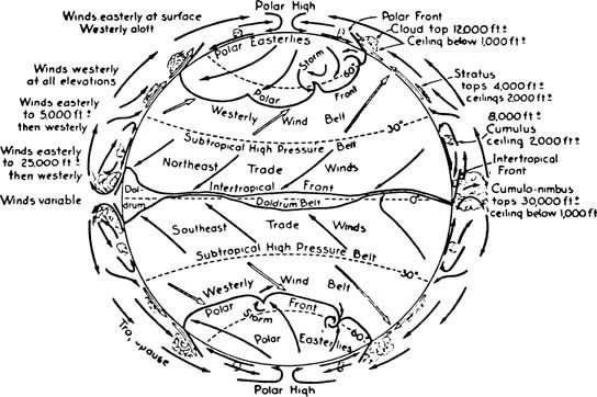
The first of these is the trade winds, a band of east-to-west prevailing winds known well to sailors, having helped early sailing ships shorten their travel time from European and African ports on their journey to the Americas.
These winds form between about 30 degrees north and 30 degrees south of the equator, in a region dubbed the "horse latitudes" for unfortunate reasons.
During an El Niño the trade winds over the Pacific weaken.
This is a crucial step in the development of El Niño, helping lock it into place for a prolonged period of time, as the weaker trade winds reinforce the initial oceanic warming in the central and eastern Pacific.
But right now, NOAA data shows the current winds are still blowing strong.
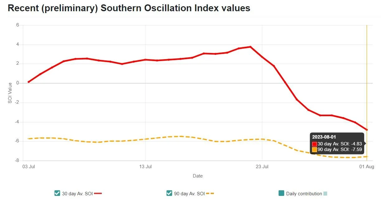
Another key sign of the atmosphere coupling is the Southern Oscillation Index (SOI), a measure of pressure between Tahiti and Darwin.
This is currently on the verge of El Niño values, having now met the threshold — but only just.
The Southern Oscillation Index has just fallen into the El Niño threshold.
Over the past two weeks, it dipped down to El Niño thresholds, bringing the 90-day average to below -7 which is indicative of an El Niño.
The BOM also looks to cloudiness near the Date Line as an atmospheric indicator.
During El Niño, the central Pacific becomes cloudier and convection migrates away from Australian longitudes to the east.
But at the moment, cloud amounts remain near average.
And finally, the upper levels winds are another indicator. Westerly winds about 10 kilometres above the ground weaken during El Niño, but they too, remain near average.
Bureau breaking its own rules
The bureau does not need to see all of these things happen to declare an El Niño.
Its criteria states at least three of the four following indicators must be met for an El Niño to be underway:
Sea surface temperature: Temperatures in the NINO3 or NINO3.4 regions of the Pacific Ocean are 0.8 °C warmer than average.
Winds: Trade winds have been weaker than average in the western or central equatorial Pacific Ocean during any three of the last four months.
SOI: The three-month average Southern Oscillation Index is –7 or lower.
Models: A majority of surveyed climate models show sustained warming to at least 0.8 °C above average in the NINO3 or NINO3.4 regions of the Pacific until the end of the year.
Technically, with the 90-day average SOI at -7, three out of the four have now been met.
But because the SOI has been "bouncing around" so much over the past few months, the bureau isn’t confident it will stay that way.
In its fortnightly climate update on Tuesday afternoon, the bureau said the "wind, cloud and broad-scale pressure patterns mostly continue to reflect neutral ENSO conditions".
Ultimately the bureau needs to be satisfied it will last for months to seasons before declaring El Niño is underway.
If changes in the atmosphere are only temporary, then the downstream impacts to places like Australia are negligible due to everyday weather fluctuations.
Why has it been so hot?
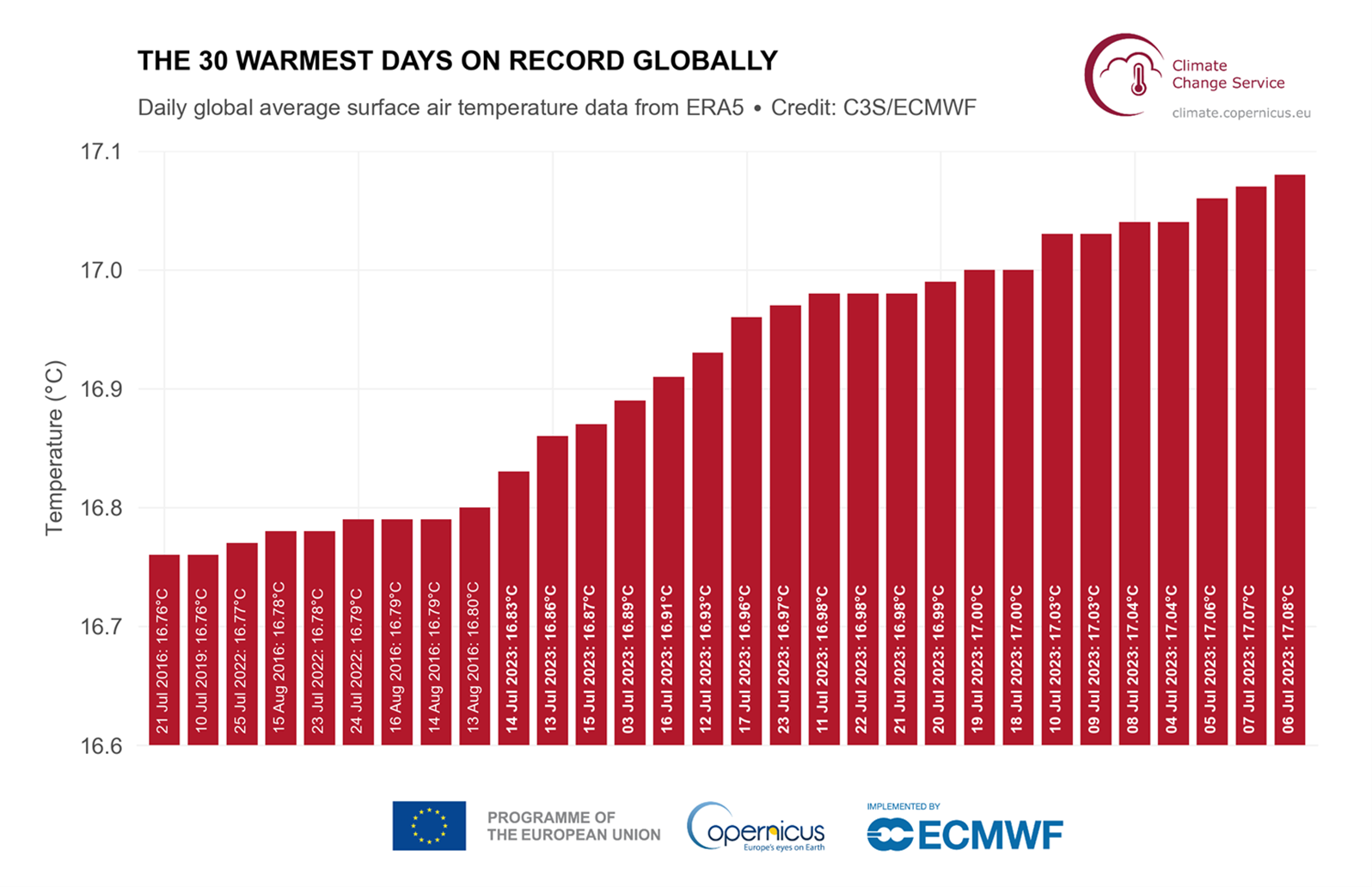
This July has been Earth's hottest month on record, globally, according to the World Meteorological Organization, with preliminary data from the EU showing 21 of the 30 hottest days ever occurred last month.
According to data from the EU, 21 out of 30 of Earth's hottest days on record have occurred this month.
But climate scientists and meteorologists say there is little evidence the record July temperatures are due to El Niño.
For Australia, the mid-winter warmth has been mostly the result of cold fronts retreating to our south, which is allowing subtropical air to linger for weeks — and that's not related to weather patterns over the Pacific.
As for the northern hemisphere, climatologists have said the extreme heat events have been driven by localised weather patterns, and likely exacerbated by climate change.
With El Niño known to increase global average temperatures, usually in the year following, climate scientists have raised concerns the worst is yet to come.
El Niño is an event that takes place in the Pacific and it is not possible for there to be an event in one part of the world but not the other.
The differing stance this year on its status simply means the US and Japan are satisfied it is underway in the Pacific, but Australia's weather bureau is not yet ready to agree.
Just how much longer it will take for the atmosphere to link with the ocean is uncertain.
Meteorologists say it could be weeks or maybe a month or two, but an El Niño in 2023 is still the most likely scenario.
Should an event be declared as underway, it gives forecasters more predictability in the long-term outlook for summer, according to the bureau's national manager of climate services, Karl Braganza.
But he said the long-term outlook, which takes into consideration a range of factors that influence the climate, had indicated the next three months would be largely warm and dry for Australia anyway.


