
A Concrete Scar in the Pacific
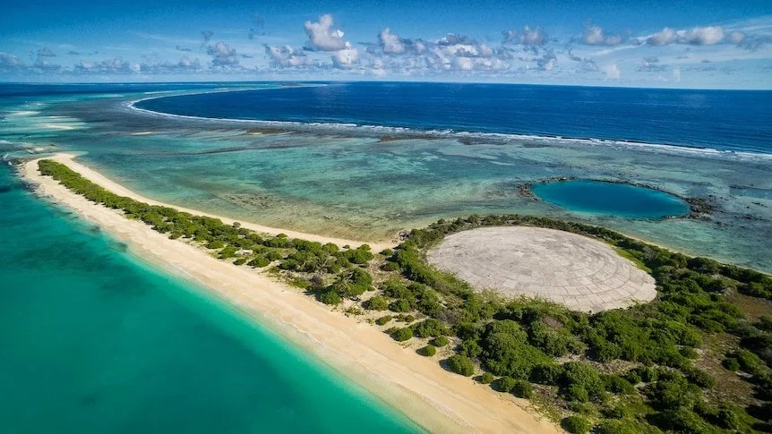
Less than 200 nautical miles from Australia’s mainland, deep in the central Pacific, on a tiny island called Runit, stands a massive weathered concrete dome — in global terms it’s on our doorstep. Officially known as the Runit Dome, this structure covers a crater filled with radioactive debris left behind by the United States’ nuclear testing program during the Cold War. In the arial photographs it looks like something from a James Bond film, but beneath it lies one of the most toxic (in the old fashioned sense of the word) legacies of the twentieth century.
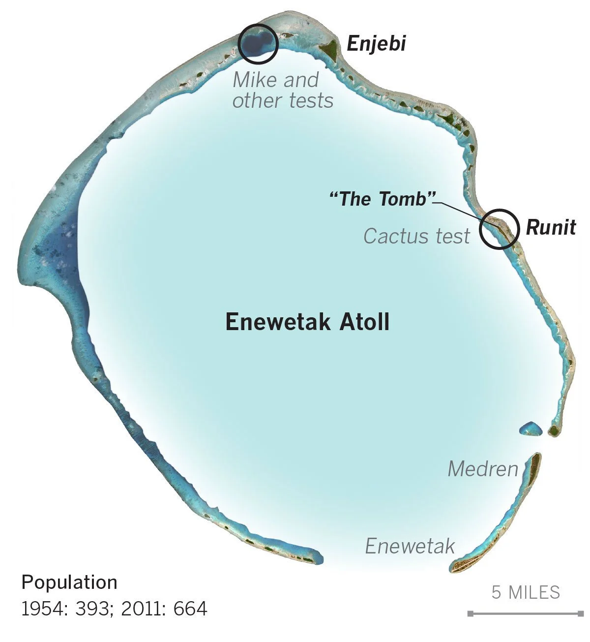
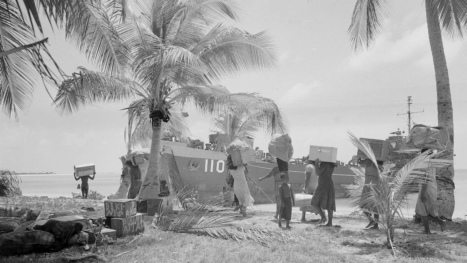
Between 1946 and 1958, the U.S. military conducted sixty-seven nuclear detonations across the Marshall Islands, using Enewetak and Bikini Atolls. Entire islands were vaporized, and thousands of Marshallese were displaced from their ancestral homes. When the tests finally finished, the land and lagoon remained contaminated with plutonium, cesium, and strontium isotopes — materials with half-lives stretching into tens of thousands of years.
Mushroom cloud forms over Bikini Lagoon in the Marshall Islands, May 1946
The “Cactus” nuclear test in 1958 left a 115-metre-wide crater in Runit Island’s coral surface. This would later become the burial site for radioactive waste.
In 1958, the “Cactus” test left a gaping crater in Runit’s coral bedrock. Two decades later, when a cleanup operation began, U.S. forces chose that crater as a dumping site for contaminated soil and debris gathered from across Enewetak Atoll. Between 1977 and 1980, roughly 85,000 cubic metres of radioactive material were buried there and capped with concrete 46 centimetres thick. Locals came to call it The Tomb.
The Runit Dome was never intended as a permanent fix. Engineers knew the porous coral beneath it could allow seawater to move freely, but lining the crater was deemed too costly. The concrete cap was built quickly, designed to contain the waste for perhaps a few decades — not centuries. Today, the structure is cracking under the continuous exposure to salt, sun, and the sea.
The Marshall Islands are among the most climate-vulnerable places on Earth. As sea levels rise, storm surges and king tides increasingly wash over low-lying atolls like Enewetak. Scientists fear that as water infiltrates the coral beneath the Dome, radioactive material could slowly leak into the surrounding lagoon — or that one powerful typhoon could crack the aging cap open entirely.
For the Marshallese, the Dome represents far more than an environmental hazard. It’s a monument to colonial exploitation and nuclear injustice — a toxic inheritance left by a distant power. Displaced communities still live with the consequences of testing: elevated cancer rates, contaminated food chains, and unfulfilled promises of restitution. U.S. servicemen who took part in the cleanup have also reported radiation-related illnesses.
The Runit Dome exemplifies the collision of two global forces — the radioactive legacy of the nuclear age and the environmental upheaval of climate change. The toxic debris of the 20th century now meets the rising seas of the 21st. As water levels rise, so too does the urgency to address what lies beneath that dome. No one seems to be able to say for sure how long the structure will remain intact. Engineers debate whether reinforcing it is feasible, while others advocate for removing the waste altogether — a task as technically challenging as it is politically fraught.

The Runit Dome Under Construction 1980