
Tom’s Pacific Journey - A Significant Change of Course
The Latest Update From The Intrepid Tom Robinson & His Shore Team

Dear Sponsors, Supporters, Family and Friends. On Friday, 19 August, Maiwar made a significant change of course; for the first time since he left Peru nearly seven weeks earlier, Tom was travelling south rather than north - steering away from the equator rather than towards it.
He was just 200 nautical miles south of the equator and 1,200 nautical miles west of the coast of Ecuador. More importantly, the beckoning Equatorial Current now had him in her bosom.
In the seven weeks since leaving Peru (on 2 July), MAIWAR had averaged 230 nautical miles per week. With the help of the current, in the first week since changing course she was travelling at the rate of 250 nautical miles per week. In early August, Maiwar’s average speed since she left Lima was 1.15 knots. At the time of writing her average speed since leaving Lima had increased to 1.3 knots, with some daily averages of over 1.5 knots.
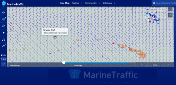
In the Marine Traffic map below, MAIWAR is the identified pleasure craft. The Galapagos Islands surrounded by blue vessels are in north east corner while the brown squid fishing fleet to the south is still at work. The background is comprised of wind barbs which show direction and speed.
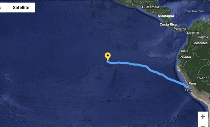
From Lima to The Marquesas is a distance of approximately 3,650 nautical miles, so half way is 1,825 nautical miles. Tom should pass this mark at the end of August, after two months at sea. His task now is to travel those remaining 1,825 nautical miles while, at the same time, steering Maiwar from 200 miles south of the equator to the latitude of The Marquesas which is a further 340 nautical miles south. To do this he must harness the current as much as he can while ensuring that the south east winds do not push him too far north. In the recent tracker screen shot below, Tom’s first-leg destination, The Marquesas, can be seen as the chain of extinct volcanoes a little north of west of Lima and close to the left hand margin.
As a way of minimizing northern drift, Tom’s good friend Peter Davies suggested that I ask Tom if he had thought of deploying his sea anchor while not rowing. I texted this suggestion to Tom and lo and behold within minutes he replied “sea anchor off stern now, feeling fantastic, it keeps getting better out here”. Tom, who calls Peter the “Sandgate Savant”, has written a blog about him. This will soon be posted in the blog section of Tom’s website at https://www.tomrobinsonboats.com/
Tom also had a good story to tell about his encounter with an Ecuadorian vessel seven weeks after he left Lima. At the time he was alone in the middle of nowhere about 800 nautical miles west of the Galapagos Islands. This is his story:
“Day 49: Ecuadorian tuna fishing ship sighted. They lowered speedboat, two men approached, ‘no English‘, pirates? Silence. They smiled, phew. I rubbed my belly. They nodded. The ship approached, a dozen men looked down and waved. The speedboat returned with boxes of goods. Bully beef? Onions? Rice? I wish. Potato chips, Powerade and cigarettes instead! Once again led astray by my limited Spanish. ‘Muchas gracias! Adios amigos!’ I howled with laughter as the ship disappeared over the horizon.”
Returning to the story of Tom’s squid fleet avoidance in our last email, the photo below is of a bigger than average Jumbo Flying Squid. It’s the smaller version of this species that are being caught by the fishing fleet which Tom skirted around in early August. Apparently they can fly for up to 30 seconds at a time, covering a distance of 30 metres. They obtain aerodynamic lift from the fins at the top as well as from webbed tentacles.
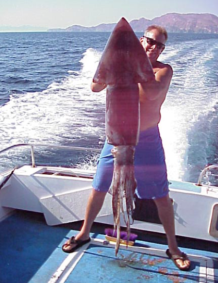
Photo courtesy Keith Williams at https://www.mexfish.com/fish/hbsquid/hbsquid.htm
Some of the more careful followers of Tom’s tracker will have noticed that the information in the box that appears when one of the blue position dots is clicked includes MAIWAR’s altitude. You can see that it is recorded as 52 metres in the screen shot of his tracker below. While usually reported as zero, you can see that sometimes it is recorded as much more. Indeed, one of Tom’s aunts asked if he was on the top deck of a cruise liner!
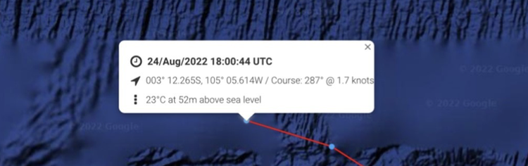
Fortunately, one of Tom’s loyal and generous supporters, Rob, has provided the shore team with an explanation for these discrepancies. Here is a summary:
Whereas a vessel’s position requires triangulation from three satellites, altitude requires at least a fourth; and at least one of these needs to be directly overhead for an accurate reading. Furthermore, because the density of the ionosphere affects the speed of signals, an additional complicating factor is introduced. There is a rule of thumb that says that vertical error is three times the horizontal error. A modern GPS receiver might thus give an elevation figure with a 10 to 20 metre error. See https://geoawesomeness.com/accurate-altimeter-gps-watch/
Thanks for the explanation, Rob.
All things considered, Tom is going well. Using human power, he’s travelled more than 3,000 kilometres in two months with nary a suggestion of trouble.
Yours Sincerely,
Tom’s Shore Team
Post Script:
In spite of his best efforts Tom has taken a northern detour again as the south east winds override the current. He’ll have to take every opportunity to get south when he can.
For background on this adventure visit
https://southernwoodenboatsailing.com/news/design-build-and-row-how-to-cross-the-pacific
https://southernwoodenboatsailing.com/news/maiwar-amp-tom-arrive-in-peru
https://southernwoodenboatsailing.com/news/and-were-away
https://southernwoodenboatsailing.com/news/the-equatorial-current-beckons
https://southernwoodenboatsailing.com/news/current-affairs-squid-squeeze-and-relaxation
And don’t forget to check Tom’s tracker and GoFundMe Page